Haiti’s economic development reposes in its willingness to decentralize the country. We can no longer afford to look at Haiti as the republic of Port-Au-Prince. While Port-au-Prince is the capital of Haiti, most of the Haitian population live outside of Port-au-Prince. One of ODIHA’s goal is to make every one of the ten departments of Haiti as important as Port-Au-Prince. To do this, we need your support and participation.
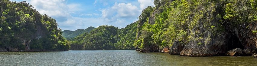
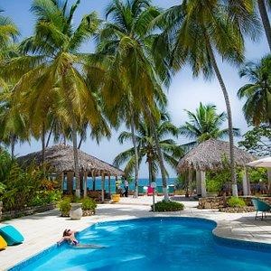
Haiti is a country with so much to offer. This Caribbean island, has beautiful beaches, lush rain forests, and a rich culture. The landscape varies greatly from mountains to plains, coastal lowlands to valleys of coffee plantations.
The best places for tourists are located in Port-au-Prince where you can find great museums, world famous restaurants as well as shops that sell Haitian arts and crafts such as paintings, sculptures and pottery made from local materials like clay or wood.
Haiti is one of the most beautiful places in the world, and has a rich history that you will never forget. With so many tourist attractions to choose from, it can be difficult to know where to start. The first thing you should do is decide on what kind of traveler you are: Do you want seclusion or adventure? Here are some suggestions for our top Haiti Tourist Attractions!
Citadelle La Ferriere – (2 115 km2) Populations of 1,067,000
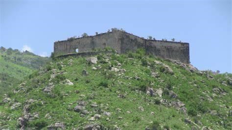
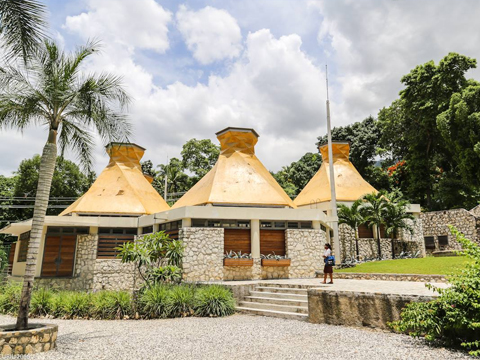
Located in Haiti’s capital city of Port-au-Prince, the Citadelle La Ferriere is a massive fortress that was originally built to protect Haitian slaves from France and provide protection for any future rebellions. The construction started in 1805 and took about 14 years before it could be completed. It became an important symbol during the slave revolution because many Haitians who fought against slavery were educated at this site due to its proximity to Fort Liberty which served as one of their military bases. Today, tourists can tour inside the fortification walls but there are no tours available onsite as it remains operational today with only 350 soldiers stationed here!
Labadie is a beach resort near Cap-Haitian in Haiti on the Atlantic coast. It was developed by Royal Caribbean Cruises, and it has been operated solely by them since 1997. The resort includes shops, restaurants and beaches with water sports facilities available for guests to use at no additional charge. Labadie is best known for its beach, which is one of the nicest in Haiti. Labadie was created by Royal Caribbean Cruises and they have operated it since 1997. Labadie has nice beaches with water sports available at no additional charge for guests to use. It also features shops and restaurants that are open all day long so you can enjoy an afternoon snack or nightly meals.
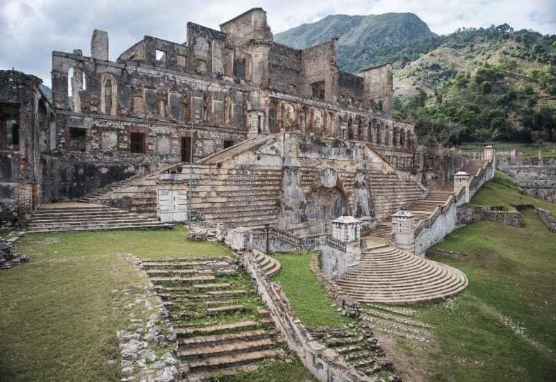
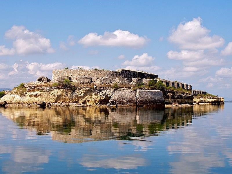
The Sans Souci Palace is a palace in Milot, Haiti where the Haitian emperor Henri Christophe lived. It was built by Henri’s imagination and completed as his summer residence on June 16 1818. The grounds were designed to imitate those of Versailles for it served not only as an imperial villa but also had many agricultural functions such as livestock to produce milk, crops like cotton that could be exported to France or processed locally into cloth, a fruit orchard with citrus trees from Europe and cedars imported from Lebanon. Tourists come here to visit the palace and enjoy its tranquil gardens. The Sans Souci Palace is a beautiful example of Haiti’s rich culture, history, and natural beauty. Explore Sans Souci Palace to gain a deeper understanding of the Haitian culture. Be sure to take in its breathtaking views and stunning architecture, as well
(2034 km2) Population of 632,601
Jacmel, on the southern coast of Haiti, is Haiti’s second largest city and a popular destination for travelers. Tourists can explore Jacmel as they walk through its small streets or take in a local dance show at one of the many cultural centers. The highest point in Jacmel is Fort Jacques where visitors can enjoy a panoramic view of this quaint town while taking in their surroundings.
The architectural wonders found throughout this town are preserved by UNESCO World Heritage Sites such as Saint Jacques Cathedral to honor their importance in history and to preserve them for future generations. The South-East department contains 11 Counties.
(4,983) populations of 4, 029,705
The National Museum of Haiti is located in Port-au-Prince, and it houses a collection that includes artifacts from the country’s history. The museum has been open to the public since its founding on December 22nd 1894 by decree, but did not become official until 1900. In 1915, under President Vilbrun Guillaume Sam they began adding more items such as paintings and sculptures which are still housed today.
The National Museum of History and Geography – formerly known as “Museum d’Histoire Naturelle” which opened in 1894, is an excellent place to visit. It features a vast collection that includes artifacts from the country’s history such as paintings and sculptures which are still housed today. Most recently, there have been efforts to provide better lighting for these exhibits so people can enjoy them during nighttime hours. The West is subdivided by 19 counties.
(1,024.56) populations 774, 976.
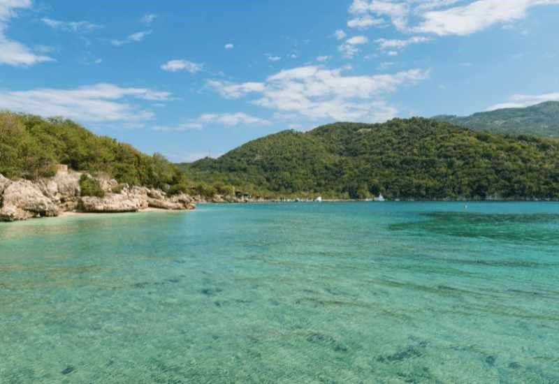
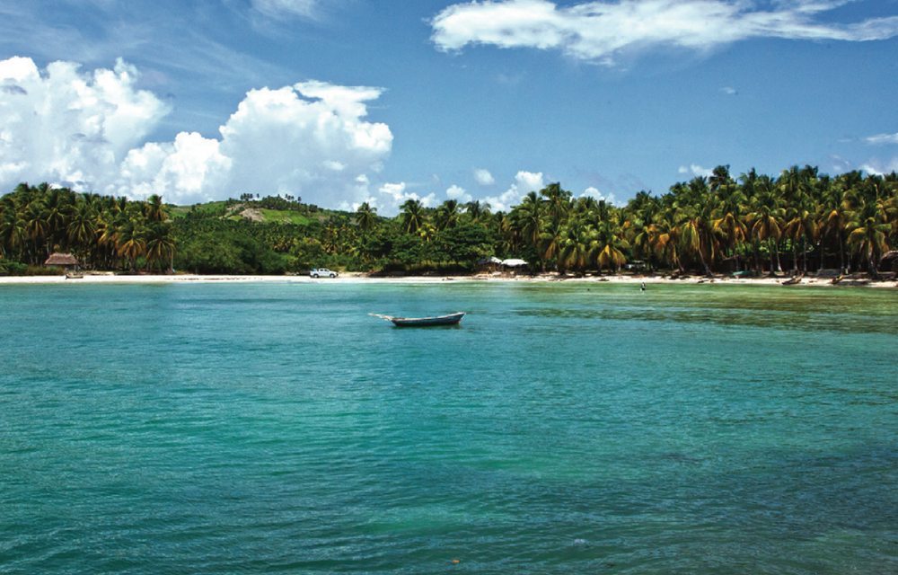
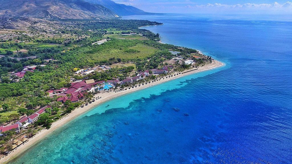
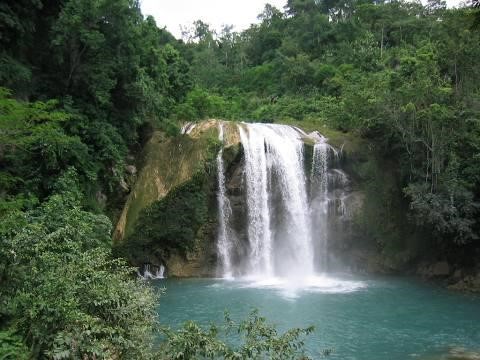
The Saut-Mathurine Waterfall is located near the town of Fond Jean Marie Vincent, and it features a massive waterfall that drops around 400 meters into a river below. Visitors can enjoy hiking along this rugged trail with views of lush greenery on all sides as well as falls throughout the journey. There are also several hiking trails in the area that feature less of a steep drop. The Nakanchelle trail is a great example which features an incredible 600-meter fall and plenty of greenery on all sides as well as waterfalls to explore along the way. Gelee Beach Gelée Beach is the perfect spot for snorkeling and scuba diving. With crystal clear waters, this beach has a nice sandy bottom that makes it great for swimming and sandcastle building. It’s also possible to see stingrays in certain spots along the shoreline as well as small turtles which can be quite entertaining when they swim by. Gelee beach is the longest sandy beach in Haiti. Gelee beach is located at the north of Haiti. Its name is derived from its crystalline waters and white sand which looks like egg whites when they come in contact with sunlight because it reflects. It’s a very popular tourist attraction for people to visit all year around, but specially during the high season of December thru April. The South Department is subdivided in 18 Counties.
(1,268 km2) Populations 342,525
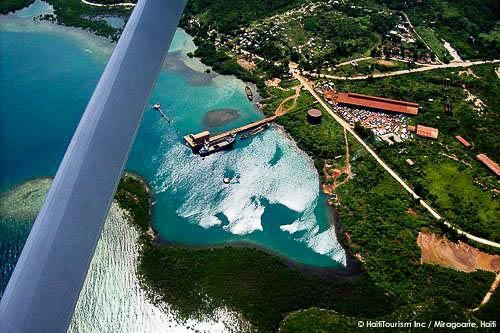
The department of Nippes is characterized by a relief consisting of plains, valleys and mountains. It has 3 important watersheds identified at the country level. Those are the Corail catchment areas – Anse à Veau, Grande Rivière de Nippes, Petite Rivière de Nippes – Grand-Goâve. In addition to these large basins, there are important micro-watersheds sometimes extending to two or three communes. Its geographical position makes it vulnerable to cyclones and depressions. The Nippes department is also characterized by a relatively dense hydrographic network. 386 water points including 226 springs and rivers are identified. The main rivers are the Grande Rivière des Nippes, the Baradères River and the river Bossard. It is worth noting the presence of the Miragoane Pond which extends over 24 km2 (9 sq. mi.)The Nippes River is the most important of the department and one of the most important in the country. Nippes has one of the biggest and most well-preserved bays in Haiti. The Baradères Bay is formed by the Baradères Peninsula and protects multiple minor islands and cays like Picoulet and Corny Island. (Pleistocene) Oldest Fossil Listed: 2.59 Ma (Pleistocene) Fossils from Region: Nippes has great mining potential in bauxite since the town of Miragoanes had a major bauxite plant operated by Reynold’s company.
(4 887) Populations 1, 728,000
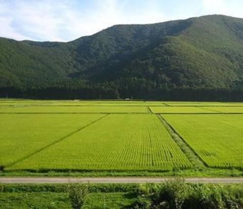
The department is bordered to the north by North and North-West, on the west the Gulf of Gonave, the south West and the east and Centre. A core geographic feature of this department is the Artibonite River, which runs through the southern half of the department, allowing for rice cultivation in the Artibonite Valley. The department has two mountain ranges running from NW to SE. On the North shore of the Valley is Black Mountain and on the south shore is Mattheux Mountain. The Bay of Gonaives is one of the best-protected bays in the country. The Bay of St-Marc is the biggest U-shaped bay in the country. The department doesn’t have any major fault line through it. he department has been in a state of economic decline since insurgencies and coups have reduced the nation’s stability. Since the election of President René Garcia Préval, the production of rice and other crops has been increasing. The biggest economical catastrophe in the department is the Clinton induces low-tariffs on rice coming from the US, destroying the local economy. Nonetheless, the economic potentials are multiple and over multiple industries. Subdivided in 18 countries..
(3, 487 km2) populations 746,236
The department played a big part in the Revolution serving as maroon territory extending to the Baoruco. Toussaint Louverture capture the town of Hinche from the Spanish for the French making it an early Haitian territory. Hinche: Former Dominican territory. Siece to Republic of Haiti in 1929. Birthplace of Charlemagne Péralte, the leader of the Cacos movement, which opposed the American occupation in 1915.
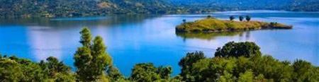
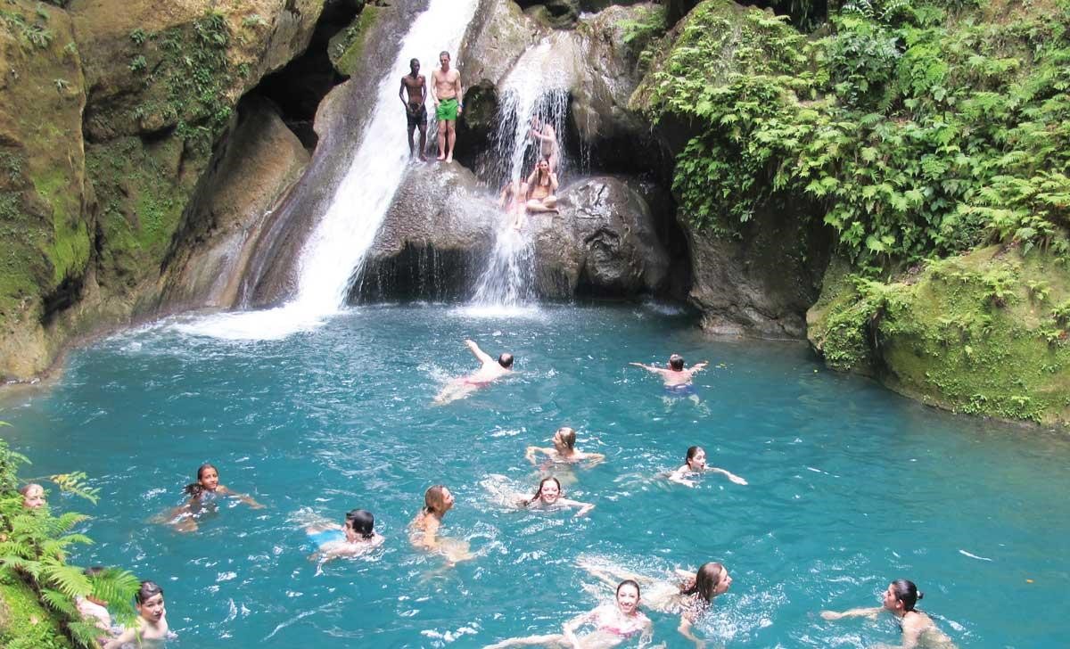
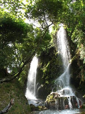
Mirebalais and Lascahobas: Place of bloody fighting of Toussaint Louverture against the English, who were resupplying in the Central Plateau (1795). Birthplace of Benoît Batraville. It contains the second largest lake in Haiti Lake Péligre, which was created as a result of the construction of the Péligre Dam on the Artibonite River during the 1950s. It is the largest hydroelectric dam in the Caribbean. The Centre department is a high plateau topographical region. Due to its isolation if one of the greenest departments. Saut-D’Eau is ts name is French for ‘waterfall’, named after a large waterfall called ‘Le Saut’. It is said that this waterfall was created in the massive earthquake of May 7, 1842.[2]: 9 The waterfall is approximately 100 feet high and is the tallest in Haiti.[3]: 204 The area holds cultural significance in Haiti, to both Catholic and Vodou practitioners. In the 19th century, it is believed that the Virgin Mary of Mount Carmel (or the closely associated Erzulie Dantor, a Vodou loa) appeared on a palm tree there. In some accounts, this appearance is said to have occurred during the 1860s.[3]: 204 Another account states that there were two appearances of the Virgin in the 1840s and later in the 1880s.[4] : 170–171 [5] In Laguerre’s detailed account, an apparition of the Virgin Mary first reported in Saut d’Eau on July 16, 1849, by a man reportedly named Fortune Morose.[2]: 10–11 In numerous oral accounts collected by Laguerre from local people, the young man went away in fear but returned shortly accompanied by a police officer. Together, they found a portrait of the apparition on the leaf of a nearby palm tree.
Trees where the apparition took place are reported to have been cut down by French priests. In Laguerre’s description, the locals “have fresh in their memory” The department of centre is divided in 13 Counties
(1 912 km2) Populations of 468,130
The department is bordered in the north by the Gulf of Gonave, west by the Windward Passage connecting to Jamaica, south by the South Department, and east by the Nippes Department. It is one of the smallest departments but it is one of the most pollutant-free due to its isolation. The westernmost point in Haiti at Cap les Irois is located in Grand’Anse. The Macaya mountain chain in the Massif de la Hotte holds the second-highest mountain in Haiti and is one of the most important environmental reserves with multiple endemic animals and plants; the Plantain Garden-Enriquillo faultline passes through it as well. Because of the mountains, it does not have a major plain or plateau for agriculture; however, the Jeremie Valley is still a major agricultural hub. Rivers in the department include the Grand’Anse and Voldrogue rivers. Grand’Anse features many islands, such as Grande Cayemite, Petite Cayemite, the Cayemite reefs and cayes, and Navaasa Island. Navassa is currently the subject of a territorial dispute between Haiti and the United States, which administers it through the US Fish and Wildlife Service. Subdivided by 12 Counties.
(2 103 km2) Population 728, 807
Capois-Lamort (dit Francois) commander of Port-de-Paix is a signatory of the Haitian Declaration of Independence. Francois Cappoix the brilliant and vaillaint Haitian officers was trapped by Henry 1st men and assassinated in Limonade. The department was in open rebellion with the Crown. Pétion in the West who needed ally after the rebellion of Rigaud in the South and Goman in the Grand’Anse, sent troops to support the N-O. Henry 1st crushed the rebellion and granted amnitice to the rebelled troops.
The town of Môle Saint-Nicolas is in the Nord-Ouest. Ever since Columbus landed here in 1492 and named the island Hispaniola, Môle St-Nicolas has been of interest to the colonials, including the British, Spanish, French, and the Americans due to its strategic location on the Windward Passage, just miles from Cuba. Tortuga island, once the biggest pirate base in the Caribbean is a popular tourist site and is represented frequently in films and movies based on piracy. Named for the smooth shape that reminded travelers of a turtle’s shell, Tortuga’s best beach is Pointe Saline at the western tip of the small island. The Mole-St-Nicolas affair was a diplomatic incident between the Haitians and the Americans because the Americans wanted a safe harbor to control the Windward Passage after the construction of the Panama Canal. The Haitian intellectual Anténor Firmin was remarkable in that affair. Mole-Saint-Nicolas Sometime during the 19th century, it was created out of he Nord and Ouest departments. Subdivided by 11 counties Mole Saint-Nicolas has the older fort in the Haitian histories of the country names La Poudriere below.
(1 623) Populations 393, 967
After the Treaty of Ryswick, the town fell into the hands of the French and they establish the town of Fort-Dauphin the actual Fort-Liberty. Many times the Spanish of Montechristi attacks the French resulting in a massacre at the Massacre River. This was a precedent of the Trujillo induce, Haitian Massacre in Dajabòn in 1937, called the Parsley-Perejil Massacre.
The Nord-Est forms part of the northern plains, a historic site of colonial plantations and a key area for the cultivation of chestnut. Toussaint Brave freed the city of Fort Liberté on September 9th, 1803. After the Battle of Vertières, on November 29, in the town of Fort-Liberté, Jean-Jacques Dessalines, Henry Christophe, and Auguste Clerveaux declared St-Domingue free and declared: Most of the department is part of the Plaine-du-Nord-Cibao-Valley with the southern part being the Massif-du-Nord. The coastal plain has the Bay of Caracol, the biggest mangrove forest in Haiti and the Bay of Fort-Liberty, the island’s only bilobal pouched-shape bay of the island is 5 times the size of the Bay of Havana.Tee bay harbors many islands, cays, and reefs. The biggest island in the Bay is Bayo Island.
The most important rivers are the Manon River and Massacre River.
Three Bays Protected Area is the most important park in the department. The Nord-East department is subdivided by 13 Counties. Fort Saint Joseph below is in Fort Liberte.
Largest waterfall in Haiti located in Camp-Perrin, Sud. The source of its stream of water comes from the Riviere de Cavallon
Fomburn
Pic Macaya National Park is one of two national parks of the Republic of Haiti. It is located in the country’s southern peninsula, within the Massif de la Hotte. Featuring the country’s last stand of virgin cloud forest, it encompasses more than 8,000 hectares. Elevations in the rugged park reach a maximum height of 2,347 meters above sea level at Pic Macaya, the second highest point in Haiti behind Pic la Selle. A majority of the park is composed of two tall peaks: Pic Macaya and Pic Forman. The park was founded in 1984, under the administration of Jean-Claude Duvalier. Originally composed of about 2,000 hectares, the park was expanded to more than 8,000 hectares in March 2013 as part of the Macaya Project. In December 2012, $12 million was pledged through 2017
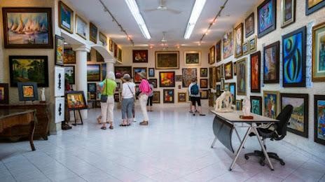
Expressions Galerie D’Art is in Port-au-Prince, Haiti. It is one of Haiti’s largest galleries, with an extensive collection of Haitian art works. It was founded 31 years ago with a collection of contemporary Haitian art. The gallery later relocated to larger new premises down the hill of Montagne Noire in Pétion-Ville.
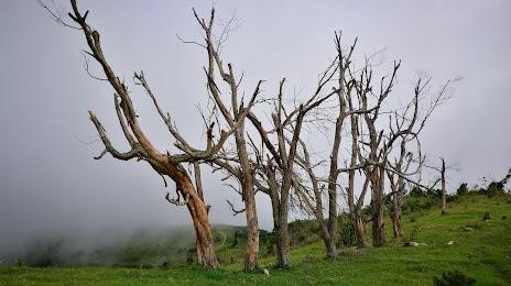
A vast expanse of tropical and subtropical coniferous forests straddling the border between Haiti and the Dominican Republic, the Forêt de Pins is located in the south-east corner of Haiti, on the Chaîne de la Selle mountain range.
Fresh air, deep tree cover and hiking opportunities make the Forêt de Pins a sought-after destination for active travellers looking for adventure and the chance to get close to Haiti’s wildlife, birdlife and nature. The forest also contains Haiti’s highest mountain, Pic La Selle, which reaches 8773 feet. Pic La Selle offers spectacular views over the dramatic landscape of Hispaniola and climbing the peak, including travel from Port-au-Prince, can easily be done in one weekend.